JAMES COOK AND NEW SOUTH WALES

Watercolour of Captain James Cook, c. 1780s. Courtesy State Library of New South Wales
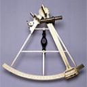
In 1768, England sent an expedition to Tahiti to chart the transit of Venus across the sun. James Cook, a brilliant Royal Navy navigator and map maker, was in charge of the expedition on the converted coal carrier HMS Endeavour. After completing the astronomical task of observing the transit of Venus, Cook set out to see if there was a Great South Land – the land that navigators had believed existed for hundreds of years.

Cooks Landing at Botany Bay A.D.1770, Town & Country 1872. Courtesy National Library of Australia
After circumnavigating New Zealand, Cook’s expedition sailed west for Van Diemens Land (Tasmania) but winds forced the Endeavour north and the expedition came upon the east coast of Australia in April 1770. For the next four months, Cook mapped the east coast from Eden to the Gulf of Carpentaria. At a brief and simple ceremony at Botany Bay, Cook named the entire east coast of Australia New South Wales.