Era: 1770 Cultural background: English Collection: British National Maritime Museum Theme:Boats Cook Exploration Science
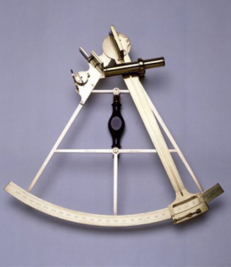
James Cook’s sextant, c. 1770. Courtesy British National Maritime Museum
Collection
British National Maritime Museum, London, England.
Object Name
Sextant.
Object/Collection Description
Sextant used by Captain James Cook on his third Pacific voyage. Made in London by Jesse Ramsden, c.1770. Brass. Dimensions 425 mm x 445 mm x 95 mm.
The existence of Terra Australis or ‘Land of the South’ was mooted by early navigators and, little by little, evidence of its existence was mounting. Slowly contact was made, first by the Spanish, led by Luis de Torres in the north, who sailed through the strait between New Guinea and Cape York in 1606. The Dutch came next with Janzoon (1606) and Hartog (1616) in the west and Abel Tasman (1642) in the south at Van Diemen’s Land. The Dutch mapped parts of the continent naming it New Holland, but showed no further interest. The first navigator to search for the east coast of Terra Australis was France’s Louis Antoine de Bougainville who in 1768 approached the Great Barrier Reef off the coast of Queensland but was turned away by the surf.
The English expedition to the South Pacific led by James Cook finally established that there was a Land of the South. After completing the observation of the transit of Venus across the sun at Tahiti in 1769, Cook’s secret instructions were to explore the South Pacific and look for the Great South Land. After exploring New Zealand and establishing that it was two islands and not the Land of the South, cook sailed further west. In April 1770 Cook sailed on to the east coast of Australia. In a simple ceremony at Botany Bay, Cook named the coastline New South Wales. During three expeditions between 1768 and 1779, Cook extensively mapped the Pacific, opening it up and revealing many of its secrets.
As a child James Cook was educated and could read and write. As an adult Cook joined the Royal Navy and was soon recognised as an excellent map maker and navigator. Using sextants and chronometer, Cook made astonishingly accurate maps of the Pacific and the east coast of Australia.
The sextant was the main tool of the navigator. Developed from the more limited octant in the 1760s, the sextant could be used either to find the height of the Sun above the horizon to determine a ship’s latitude, or measure angles between the Moon and fixed stars. The latter was a more difficult observation to do accurately on a moving vessel but, using published tables, allowed a skilled navigator to calculate his longitude as well. This particular instrument is reputed to have been used by Captain Cook on his third Pacific voyage (1776-80) and is one of four known to survive from his three expeditions. Cook used lunar-distance sextant observations made on land to check the accuracy of the experimental chronometers he took on his last two Pacific voyages.
The sextant has considerable historic significance as it is thought to have been used by James Cook, one of the greatest navigators and cartographers in European exploration history.
The sextant has aesthetic significance in that its design in 1770 was the finest Europe had to offer. It was made by Jesse Ramsden, who was one of the best London instrument makers of the late 18th century.
The sextant is significant for researchers as one of the four existing sextants used by Cook on his three Pacific Voyages. Its design and manufacture helps researchers to understand navigation, cartography and maritime exploration of that time.
The sextant has intangible significant, being an iconic symbol of one of history’s greatest navigators and explorers, the person responsible for the foundation of modern Australia.
The object is well provenanced and documented. It was acquired from a private collector by the British National Maritime Museum, London, UK, with the assistance of the National Heritage Memorial Fund.
The sextant is extremely rare. It is one of four existing sextants used by Cook on his three Pacific voyages.
The object represents a time early in Australia’s history when England was still establishing itself in the Pacific and exploring the new environment. The sextant also represents the coming of Europeans to Aboriginal Australia as it is instantly recognisable as a maritime instrument, a symbol of navigation and exploration. The sextant is in excellent condition.
The sextant interprets the themes of British exploration and colonial expansion into the Pacific and the achievements of James Cook in the European discovery and mapping of the east Australian coast.
Bibliography
Coupe, . & Andrews, M 1992, Their Ghosts may be heard: Australia to 1900, Longman Cheshire, Sydney.
Heritage Collections Council 2001, Significance: A guide to assessing the significance of cultural heritage objects and collections, Canberra.
Steven, M First Impressions: The British Discovery of Australia, London, UK, 1988.
Thompson, S 2004,Atlas du Voyage de Lapérouse 1785 – 1788,
Exhibition Essay, Lapérouse Museum, Dept Environment & Conservation.
Thompson, S 2002, Lapérouse Museum booklet, Department of Environment & Conservation, Sydney.
Thompson, S 2005, Any News of La Pérouse? Exhibition catalogue essay, State Library of New South Wales.
Thompson, S 2007,At the Beach: Contact, Migration & Settlement in South East Sydney, Migration Heritage Centre, Sydney.
Websites
Migration Heritage Centre
December 2005 – updated 2011
Crown copyright 2005©
The Migration Heritage Centre at the Powerhouse Museum is a NSW Government initiative supported by the Community Relations Commission.
www.migrationheritage.nsw.gov.au
Regional Services at the Powerhouse Museum is supported by Movable Heritage, NSW funding from the NSW Ministry for the Arts.